View the 3D digital model of canals and streams for the first time implemented in Vietnam
Ho Chi Minh City is vigorously implementing the digitization of transportation infrastructure data, including the survey and collection of information on inland waterway channels (both underwater and on land). This information is integrated into the electronic portal of the Department of Transportation and the Ho Chi Minh City Waterway Management Center to facilitate information provision and management.
During a meeting at the end of September 2023 with Portcoast Consultant Co., Ltd. (Portcoast), attended by leaders of various departments of Ho Chi Minh City, Mr. Bui Xuan Cuong, the Vice Chairman of the Ho Chi Minh City People's Committee, requested Portcoast to collaborate and support the city's departments in the application of digital technology. The survey of inland waterway channels, serving management tasks and the announcement of channels, is the initial result of this collaboration. This project represents a comprehensive digital transformation, fully based on digital platforms.
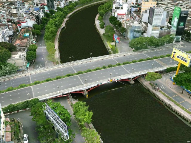
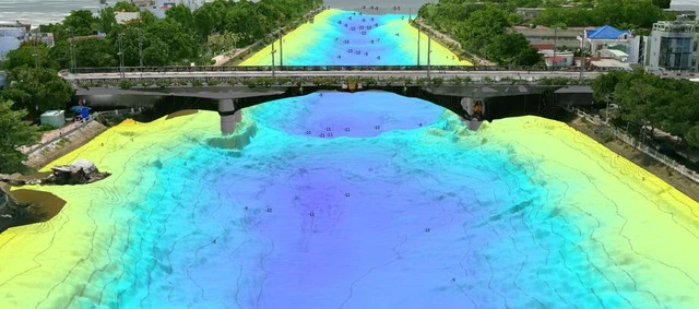
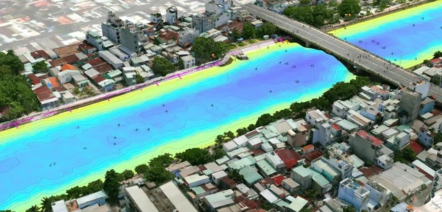
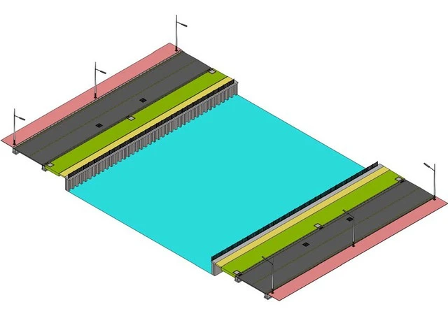
The survey product is a digital model of the current state of all 82 waterway routes in the city, with a total length of over 523 km and a total underwater area of more than 5,500 hectares. Additionally, the consulting unit conducted surveys of canal and stream banks, covering a total sloping roof area and both banks of over 10,000 hectares, along with 217 bridges and culverts; 200 high/medium/low voltage power lines and 146 ports and inland waterway wharfs. The unit also carried out the design of water channels, buoy systems according to planning and current state; as well as the design of typical landscapes along the banks of rivers for 82 canal and stream routes.
Mr. Pham Anh Tuan, the General Director of Portcoast, stated that the technology and equipment used for the survey are the most modern in the world at present (such as Survey/Scan to BIM-GIS equipment). Specifically, the unit conducted depth measurements using multi-beam and single-beam echo sounding devices, applying Real-Time Kinematic (RTK) technology with survey vessels, in combination with Unmanned Surface Vehicles (USVs) integrated with multi-beam echo sounding equipment (for underwater measurement and Lidar - on the water surface near the banks).
Following that, terrestrial surveys were conducted using Unmanned Aerial Vehicle (UAV) systems integrated with Lidar equipment, and cameras with 5-camera arrays (Photogrammetry technology); surveys of overpass structures (bridges, culverts), and detailed items using 3D laser scanning devices (scanning range from 130m to 1 km, accuracy up to mm, scanning speed of 2 million points/s); high/medium/low voltage power lines surveyed with UAVs integrated with Lidar and 3D laser scanning equipment; and surveys of riverside roads using Mobile Mapping technology.
"This is the first time in Vietnam that digital technology has been fully applied to a large-scale inland waterway project like this. The use of technology with modern equipment has shortened the survey time to just 30 - 40% compared to traditional survey methods currently in use (which produce 100% 2D products), while the technology applied to this project is much more extensive and accurate (producing 100% 3D products)," Mr. Pham Anh Tuan shared.
It is understood that the digital model of the entire inland waterway system of the city is built on an integrated platform of Building Information Modeling (BIM) and Geographic Information System (GIS). This digital model provides a 3D visual representation, fully integrating various layers of data for managing the city's inland waterways: depth of the channel, current state along both banks, overpass structures, ports and inland waterway wharfs, inland waterway signal systems, etc. This model can be said to be like a real world that can be used for planning related projects such as urban planning and beautification along rivers, riverbank protection embankments, new overpass projects, and more.
This digital model is managed and accessed at different levels, making it very easy to update any information in real time. It can be accessed anytime, anywhere, and through any digital device (computer, tablet, smartphone), serving not only the management needs of regulatory bodies but also providing accessible information to the community and residents.
This project, which applies digital technology, fully meets the requirements of the Government and the Ho Chi Minh City People's Committee regarding the application of Building Information Modeling (BIM) and the integration of construction information models into the Geographic Information System (GIS).
Below are some typical images of the comprehensive digital transformation of the inland waterway flow survey project for management and flow disclosure purposes.

Source: thanhnien.vn
Pageviews: 0
Hơn 520km đường thủy TP.HCM số hóa chuẩn theo hiện trạng
Theo tuoitre.vn - 31/12/2023
Trung tâm Quản lý đường thủy - Sở Giao thông vận tải TP.HCM cho biết t...
Hình thành Trung tâm Logistics Cái Mép Hạ cùng với chức năng Khu thương mại tự do
Theo vlr.vn - 01/12/2023
Đó là khẳng định của ông Phạm Viết Thanh, Ủy viên ban chấp hành Trung ...
TP.HCM sẽ có những cây cầu độc đáo, không lặp lại, Portcoast tận dụng máy bay không người lái để khảo sát trên không nhằm tạo bản đồ 3D
Theo tuoitre.vn - 05/12/2023
Mời bạn đọc cùng Tuổi Trẻ Online xem phối cảnh độc đáo của cầu Thủ Thi...